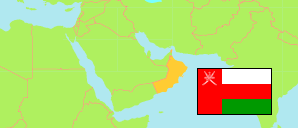
Ad-Duqm
District in Al Wusta Governorate
District
The population development of Ad-Duqm.
| Name | Native | Status | Population Census 2003-12-07 | Population Census 2010-12-12 | Population Census 2020-12-12 | |
|---|---|---|---|---|---|---|
| Ad-Duqm | الدقم | District | 4,269 | 11,217 | 19,221 | → |
| Al-Wusṭa [Al Wusta] | الوسطى | Governorate | 23,307 | 42,111 | 52,344 |
Contents: Localities
The population development of the localities in Ad-Duqm.
| Name | Native | Status | District | Population Census 2003-12-07 | Population Census 2010-12-12 | Population Census 2020-12-12 | |
|---|---|---|---|---|---|---|---|
| Al-Hawiyah | الحوية | Locality | Ad-Duqm | 110 | 500 | 773 | → |
| An-Naamiyah | النعامية | Locality | Ad-Duqm | 0 | 0 | 336 | → |
| Dhahar | ظهر | Locality | Ad-Duqm | 368 | 1,003 | 1,784 | → |
| Dithab | ديثاب | Locality | Ad-Duqm | 187 | 226 | 392 | → |
| Ghafat Mahjan | غافة محجان | Locality | Ad-Duqm | 39 | 115 | 88 | → |
| Hitam | هيتام | Locality | Ad-Duqm | 466 | 516 | 1,238 | → |
| Juwayrah | جويرة | Locality | Ad-Duqm | 166 | 209 | 295 | → |
| Nafun | نفون | Locality | Ad-Duqm | 201 | 185 | 173 | → |
| Ras Madrakah | راس مدركة | Locality | Ad-Duqm | 616 | 767 | 915 | → |
| Thalin | ثلين | Locality | Ad-Duqm | 147 | 203 | 271 | → |
| Wadi Marzam | وادي مَرزم | Locality | Ad-Duqm | ... | 68 | 82 | → |
| Wadi Say | وادي صاي | Locality | Ad-Duqm | 1,058 | 6,183 | 12,805 | → |
Source: Sultanate of Oman, National Centre for Statistics and Information (web).
Explanation: The 2020 census was organized as an electronic census.