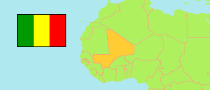
San
Cercle in Mali
Contents: Subdivision
The population development in San as well as related information and services (Wikipedia, Google, images).
| Name | Status | Population Census 1998-04-17 | Population Census 2009-04-01 | |
|---|---|---|---|---|
| San | Cercle | 250,597 | 333,613 | |
| Baramandougou | Commune | 7,011 | 9,149 | → |
| Dah | Commune | 11,859 | 12,935 | → |
| Diakourouna | Commune | 6,807 | 11,699 | → |
| Dieli | Commune | 12,436 | 13,984 | → |
| Djeguena | Commune | 4,163 | 4,039 | → |
| Fion | Commune | 5,440 | 6,504 | → |
| Kaniegue | Commune | 6,462 | 7,120 | → |
| Karaba | Commune | 6,011 | 8,691 | → |
| Kassorola | Commune | 13,349 | 16,342 | → |
| Kava | Commune | 12,478 | 18,356 | → |
| Moribila | Commune | 8,942 | 11,544 | → |
| N'Goa | Commune | 7,592 | 9,182 | → |
| Niamana | Commune | 5,007 | 9,583 | → |
| Niasso | Commune | 10,441 | 13,172 | → |
| N'Torosso | Commune | 8,372 | 10,199 | → |
| Ouolon | Commune | 9,271 | 13,313 | → |
| San | Urban Commune | 46,631 | 66,967 | → |
| Siadougou | Commune | 12,143 | 17,744 | → |
| Somo | Commune | 3,760 | 3,744 | → |
| Sourountouna | Commune | 10,019 | 12,371 | → |
| Sy | Commune | 9,294 | 12,556 | → |
| Tene | Commune | 14,890 | 20,658 | → |
| Teneni | Commune | 7,096 | 7,000 | → |
| Tourakolomba | Commune | 4,993 | 7,877 | → |
| Waki | Commune | 6,130 | 8,884 | → |
| Mali | Republic | 9,810,912 | 14,528,662 |
Source: Institut National de la Statistiques, République du Mali (web).
Explanation: In case of the 1998 census, persons assigned to no commune are included in the cercle figures.