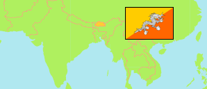
Trashiyangtse
District in Bhutan
Contents: Subdivision
The population development in Trashiyangtse as well as related information and services (Wikipedia, Google, images).
| Name | Status | Population Census 2005-05-31 | Population Census 2017-05-30 | |
|---|---|---|---|---|
| Trashiyangtse | District | 17,740 | 17,300 | |
| Boomdeling (Bumdeling) | Gewog | 1,988 | 2,142 | → |
| Jamkhar | Gewog | 1,228 | 999 | → |
| Khamdang | Gewog | 3,580 | 3,672 | → |
| Ramjar | Gewog | 1,275 | 1,213 | → |
| Toedtsho (Toetsho) | Gewog | 2,128 | 1,580 | → |
| Tongmajangsa (Tomzhangtshen, Tomzhangsa) | Gewog | 1,555 | 1,782 | → |
| Yalang | Gewog | 1,705 | 1,372 | → |
| Yangtse (Trashiyangtse) | Gewog | 4,281 | 4,540 | → |
| Druk Yul [Bhutan] | Kingdom | 634,982 | 727,145 |
Source: National Statistics Bureau, Royal Government of Bhutan (web).
Explanation: The population figures of towns and municipalities are generally assigned to an adjacent gewog. Area figures of gewogs are computed by using geospatial data.
Further information about the population structure:
| Gender (C 2017) | |
|---|---|
| Males | 8,719 |
| Females | 8,581 |
| Age Groups (C 2017) | |
|---|---|
| 0-14 years | 5,582 |
| 15-64 years | 10,498 |
| 65+ years | 1,220 |
| Age Distribution (C 2017) | |
|---|---|
| 0-9 years | 3,475 |
| 10-19 years | 3,849 |
| 20-29 years | 2,712 |
| 30-39 years | 2,363 |
| 40-49 years | 1,694 |
| 50-59 years | 1,384 |
| 60-69 years | 1,071 |
| 70+ years | 752 |
| Urbanization (C 2017) | |
|---|---|
| Rural | 13,753 |
| Urban | 3,547 |