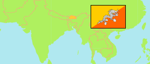
Samtse
District in Bhutan
Contents: Subdivision
The population development in Samtse as well as related information and services (Wikipedia, Google, images).
| Name | Status | Population Census 2005-05-31 | Population Census 2017-05-30 | |
|---|---|---|---|---|
| Samtse (Samchi) | District | 59,003 | 62,590 | |
| Doomtoed (Dungtoe) | Gewog | 1,326 | 1,433 | → |
| Dophuchen (Dorokha) | Gewog | 4,419 | 5,419 | → |
| Duenchhukha (Denchhukha, Duenchukha) | Gewog | 2,310 | 2,159 | → |
| Namgyalchhoeling (Namgyel Chhoeling) | Gewog | 2,811 | 3,141 | → |
| Norboogang (Chengmari) | Gewog | 3,877 | 4,075 | → |
| Norgaygang (Bara) | Gewog | 3,403 | 3,743 | → |
| Pemaling (Biru) | Gewog | 3,026 | 3,262 | → |
| Phuentshogpelri (Pagli) | Gewog | 9,311 | 7,735 | → |
| Samtse | Gewog | 8,244 | 9,002 | → |
| Sang-Ngag-Chhoeling (Chargharay) | Gewog | 3,155 | 3,061 | → |
| Tading | Gewog | 4,115 | 4,719 | → |
| Tashichhoeling (Sipsu) | Gewog | 4,074 | 4,577 | → |
| Tendruk (Tendu) | Gewog | 4,587 | 6,242 | → |
| Ugyentse (Ugentse) | Gewog | 1,536 | 1,390 | → |
| Yoeseltse | Gewog | 2,809 | 2,632 | → |
| Druk Yul [Bhutan] | Kingdom | 634,982 | 727,145 |
Source: National Statistics Bureau, Royal Government of Bhutan (web).
Explanation: The population figures of towns and municipalities are generally assigned to an adjacent gewog. Area figures of gewogs are computed by using geospatial data.
Further information about the population structure:
| Gender (C 2017) | |
|---|---|
| Males | 32,022 |
| Females | 30,568 |
| Age Groups (C 2017) | |
|---|---|
| 0-14 years | 16,884 |
| 15-64 years | 41,665 |
| 65+ years | 4,041 |
| Age Distribution (C 2017) | |
|---|---|
| 0-9 years | 10,219 |
| 10-19 years | 12,145 |
| 20-29 years | 10,969 |
| 30-39 years | 10,077 |
| 40-49 years | 7,275 |
| 50-59 years | 5,665 |
| 60-69 years | 3,718 |
| 70+ years | 2,522 |
| Urbanization (C 2017) | |
|---|---|
| Rural | 52,916 |
| Urban | 9,674 |